 This is one cool toy! It's rugged, it's
compact, it's cool-looking, and most importantly it works. I bought my Garmin
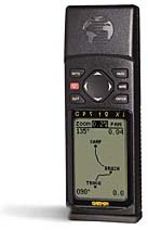
GPS 12XL personal navigation unit for a recent trip to the Mojave Desert. We
were headed to a new area that we were completely unfamiliar with. What better chance to
try out one of these devices. I carried it in a fanny-pack in front of me. It was able to
hold signal lock for most of our 200-mile ride. It provided a nifty little on-screen map
of the route we had taken – boy did we ride in circles (more details in the Rasor
Valley Trip Report)! With Pinhead in the lead, we expected nothing less. While I still
haven't learned how all of the features work, within a couple hours of playing, and very
little manual-reading, I was able to figure out most of the basic features and we were
off. I had a few hard get-offs, landing on it twice. While I knocked the wind out of
myself, it held up incredibly well. Compared to several other units, the Garmin 12XL seems
to be one of the best suited for dirt biking. With its ultrasonically welded,
dry-nitrogen-filled case, it seems to be rugged enough to stand a reasonable amount of
abuse.
This is one cool toy! It's rugged, it's
compact, it's cool-looking, and most importantly it works. I bought my Garmin
GPS 12XL personal navigation unit for a recent trip to the Mojave Desert. We
were headed to a new area that we were completely unfamiliar with. What better chance to
try out one of these devices. I carried it in a fanny-pack in front of me. It was able to
hold signal lock for most of our 200-mile ride. It provided a nifty little on-screen map
of the route we had taken – boy did we ride in circles (more details in the Rasor
Valley Trip Report)! With Pinhead in the lead, we expected nothing less. While I still
haven't learned how all of the features work, within a couple hours of playing, and very
little manual-reading, I was able to figure out most of the basic features and we were
off. I had a few hard get-offs, landing on it twice. While I knocked the wind out of
myself, it held up incredibly well. Compared to several other units, the Garmin 12XL seems
to be one of the best suited for dirt biking. With its ultrasonically welded,
dry-nitrogen-filled case, it seems to be rugged enough to stand a reasonable amount of
abuse.
It's advertised to acquire satellites in 3 seconds, compared to
other units where it could take 15 seconds to several minutes. I found it to take several
seconds to pinpoint its position, after being powered off. This seemed completely
acceptable. It is also supports DGPS for improved accuracy. During our entire test, we
were in wide-open desert. I assume performance would degrade in the heavy tree cover of
the mountains. However, an external, active antenna is available to improve performance.
How practical that would be for dirt bike riding is yet to be determined.
With the growing popularity of inexpensive GPS units, many
atlases, such as the DeLORME Atlas & Gazetteer series, are available with GPS grids.
As cool as these units are, they are no substitute for a good topographic map. If forced
to choose, I'd take the map every time. I've found it handy to enter the coordinates of as
many landmarks and nearby cities prior to heading out for a long ride. This makes it very
easy to pinpoint your location on maps.
For those into dual sport riding or riding in the open desert, it
works well to enter most/all intersections you plan to cross as waypoints. This will give
you "as the crow flies" estimates of mileage between points and a rough estimate
for the total trip. When riding in remote areas, this can assist in locating the correct
intersection, when there are so many that have never made it onto the map.
For the experienced navigator and good map-reader, this is a fun
toy. For those less experienced, it's a great idea.
Features include:
- Parallel PhaseTrac12 operating system continuously tracks up to 12
satellites for fast, accurate positioning.
- User-friendly rocker/keypad system allows room for a large backlit
LCD screen with easy-to-read characters and full-featured graphic plotting.
- Graphic presentation pages for satellite status, position,
compass, moving map plotting and CDI navigation.
- Innovative TracBack feature lets you quickly navigate back home
without marking a single waypoint. Resetable trip odometer keeps track of distance
traveled.
- Internal lithium battery - maintains important waypoints, routes,
and track log information.
- 500 alphanumeric waypoints, 20 reversible routes, sunrise/sunset
planning, and continuously updated moving map plotting with range rings.
- Ultrasonically welded, dry-nitrogen-filled case.
- Accuracy: 49 feet.
- Input voltage: The 12XL will run on 10- to 32 volts DC.
- Carry case, batteries included.

![[To Current Issue]](../../../images/Navigation/DirtHome.jpg)